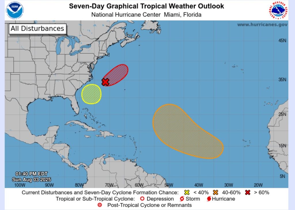
The National Hurricane Center released a Tropical Weather Outlook from The NWS National Hurricane Center, Miami, Fl, at 2:00 PM on Sunday, August 3.
While there is currently no eminent development of a storm, there is an area in the Atlantic to be aware of.
Update:
For the North Atlantic…Caribbean Sea and the Gulf of America:
- Western Atlantic (AL95):
Showers and thunderstorms have increased in association with a
non-tropical area of low pressure located a few hundred miles east
of the North Carolina coast. While satellite wind data show that
the low is now producing gale-force winds, the system remains
attached to a frontal boundary. However, environmental conditions
are conducive for this system to acquire additional tropical
characteristics, and a tropical storm is likely to form by Monday
well east of the North Carolina coast. For additional information,
including gale warnings, please see High Seas Forecasts issued by
the National Weather Service.
- Formation chance through 48 hours…high…70 percent.
- Formation chance through 7 days…high…70 percent.
- Central Tropical Atlantic:
A tropical wave is forecast to move off the west coast of Africa by late Monday. Thereafter, some gradual development of the wave is possible, and a tropical depression could form late this week while it moves generally west-northwestward across the central tropical Atlantic.
- Formation chance through 48 hours…low…near 0 percent.
- Formation chance through 7 days…medium…40 percent.
- Off the Southeastern United States:
An area of low pressure could form in a couple of days a few hundred miles southeast of the Carolinas. Some gradual development of this
system is possible by midweek as the system drifts to the northwest.
- Formation chance through 48 hours…low…near 0 percent.
- Formation chance through 7 days…low…20 percent.


